|
IN BRIEF
|
The convergence between physics and archaeology has given birth to modern detection tools that revolutionize the way we explore the past. Thanks to advanced techniques such as laser remote sensing (LiDAR) and geophysics, archaeologists can now identify buried remains without disturbing archaeological sites. These methods allow for precise mapping and localization of ancient structures while offering an innovative perspective on the evolution of civilizations. The integration of physical science into archaeological practices opens promising avenues for the discovery and understanding of our historical heritage.
The conjunction of physics and archaeology has enabled access to modern detection methods that revolutionize the way we explore and discover our past. Thanks to technological advancements, tools such as laser remote sensing (LiDAR) and geophysics provide valuable information without harming buried remains. This article highlights these innovative tools and their impact on contemporary archaeology.
Geophysics: a revolution for archaeology
Geophysics has become an essential tool for archaeologists. By using various prospection techniques, researchers can explore the subsurface in search of remains without performing invasive excavations. Methods such as magnetometry, electrical resistivity, and acoustics are employed to produce images of underground architecture, revealing secrets of our buried history.
Geophysical detection techniques
Geophysical detection methods allow for comprehensive mapping of archaeological sites. For example, magnetometry measures variations in the magnetic field of the ground that may indicate the presence of buried structures, while resistivity assesses the electrical conductivity of the ground to detect anomalies that could signal ditches or walls. These techniques allow for an initial evaluation of sites without digging.
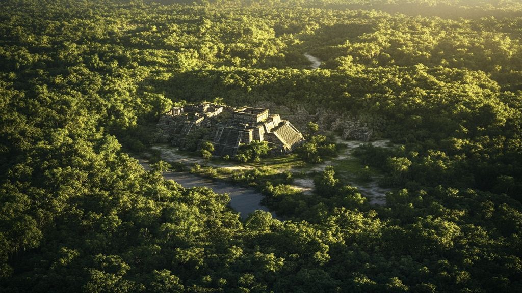
LiDAR technology: a new era for prospection
The LiDAR technology (or Light Detection and Ranging) has profoundly transformed the field of archaeology. By using lasers to scan the terrain, this method allows for accurate mapping of the topography and detection of structures that may be hidden by dense vegetation.
Applications of LiDAR in archaeology
LiDAR has allowed for the rediscovery of many important sites, particularly in Central America, where Maya ruins were hidden by thick foliage. The collected data provide a three-dimensional representation of the terrain, facilitating the mapping of ancient cities and forgotten infrastructures. This technique also offers planning possibilities for potential excavations.
Physics-assisted dating methods
Alongside detection tools, physics also plays a key role in dating artifacts. Archaeologists use dating methods such as radiometric dating, which allows for determining the age of organic materials by measuring the radioactivity of isotopes.
Importance of dating in archaeology
Dating methods provide an essential chronological framework for understanding historical and cultural events. By integrating physical data with the results of geophysical surveys, researchers can establish precise chronologies, thereby enriching our understanding of the evolution of civilizations.
Conclusion: interdisciplinarity in the service of archaeology
The combination of physical techniques and traditional archaeological methods opens innovative perspectives for archaeological research. The use of geophysics, LiDAR, and dating methods demonstrates a promising synergy between modern science and the exploration of our past.
| Tool | Application |
| LiDAR | Locates archaeological structures by revealing shapes hidden under vegetation. |
| Satellite imagery | Allows for localizing remains on a large scale with topographical details. |
| Remote sensing | Identifies soil composition and the presence of archaeological elements. |
| Geophysics | Mapping of the subsurface, detection of cavities and buried structures. |
| 3D scanners | Generate three-dimensional models of sites for detailed analysis. |
| Radiometric dating | Estimates the age of artifacts by measuring the isotopes present. |
| Drone | Captures aerial images for monitoring and documenting sites. |
| Chemical analysis | Determines the composition of materials, essential for dating. |
In the quest to unveil the secrets of the past, physics and archaeology come together through modern detection tools. These technological advances allow us to explore the subsurface without disturbing hidden heritage, offering new perspectives on our ancestors. This article examines the synergies between these two fascinating fields, highlighting the innovative techniques and tools that are revolutionizing archaeological research.
Geophysics: a valuable ally
Geophysics plays a fundamental role in modern archaeology. By using non-invasive techniques, it is possible to detect buried remains in the ground, preserving the site and its history. Methods such as resistivity, IP (induction electromagnetic), and seismic are commonly used to obtain detailed images of the subsurface, allowing archaeologists to plan their excavations more efficiently.
LiDAR: a technological revolution
The LiDAR technology (Light Detection and Ranging) has transformed the way archaeologists identify and map archaeological sites. Through laser remote sensing, this method allows for revealing hidden structures, even beneath dense forest cover. Ancient ruins, some of which were previously invisible, are now accessible because of this advancement, thus changing our understanding of past societies.
Modern dating: a precision tool
Archaeological research also relies on precise dating methods. Archaeologists use radiometric dating to determine the age of artifacts and organic materials. This technique is based on the physical principles of radioactive decay, providing reliable results that enrich our knowledge of the human timeline.
Aerial remote sensing: an overview
In addition to terrestrial tools, aerial remote sensing energizes archaeological prospection. By combining satellite images and aerial photographs, this method offers an expanded perspective on the archaeological landscape. Archaeologists can detect surface anomalies, such as ancient ditches or structures, thus facilitating subsequent research.
Innovation and collaborative research
The collaboration between physicists and archaeologists is essential for integrating these new technologies into the field of archaeology. The creation of geolocated databases, combined with data from geophysical diagnostics, allows for the construction of rigorous archaeological files. These synergies pave the way for unprecedented discoveries and deepen our understanding of human history.
The impact of volcanoes on archaeology
Finally, it is important to consider how natural phenomena such as volcanic eruptions can influence archaeological research. Volcanic ash, for instance, sometimes preserves remains at the surface. Understanding these interactions between geological physics and archaeological sites enriches our knowledge of the impact of natural disasters on past civilizations. For more information on the role of volcanoes and their influence on the terrestrial environment, check out these links: Volcanic eruption forecasts, The impact of volcanoes on the terrestrial environment, and Impact of volcanoes on the terrestrial environment.
- Geophysics: detection of remains below the surface without disturbance.
- LiDAR technology: precise mapping through dense vegetation.
- Aerial remote sensing: identification of archaeological structures on a large scale.
- Satellite imagery: observation of archaeological sites from space.
- Magnetic prospection: detection of magnetic anomalies related to remains.
- Ground-penetrating radar: visualization of subsurface layers.
- Radiometric dating: establishing the age of artifacts and structures.
- 3D modeling: digital reconstruction of archaeological sites and objects.
- Archaeological diagnostics: characterization of remains before excavations.
- Sensometry: analysis of the physical properties of soils to locate sites.
The synergy between physics and archaeology has developed modern detection tools that revolutionize research and exploration methods for the remnants of the past. Through innovative techniques such as remote sensing, geophysics, and the use of laser technologies like LiDAR, archaeologists now have the ability to explore the subsurface without disturbing archaeological sites while obtaining precise information about their structure and dating.
Geophysics and its applications in archaeology
Geophysics constitutes a valuable tool for archaeologists, allowing for non-invasive prospections. Using techniques such as seismic, magnetometry, or electrical resistivity, it is possible to detect buried structures in the ground. These methods provide detailed images of the subsurface, helping to locate archaeological remains even before proceeding to excavations. Therefore, these techniques are essential allies in archaeological research.
Imaging by magnetic resonance
One of the flagship applications of geophysics in archaeology is imaging by magnetic resonance. This process allows for analyzing the magnetic properties of materials in the subsurface, thus providing information on buried objects. By integrating this technique into an archaeological project, researchers can optimize their excavations, avoiding unnecessary disturbances.
LiDAR: a revolutionary tool
The acronym LiDAR, which stands for Light Detection and Ranging, refers to a laser remote sensing technology that radically transforms archaeology. Thanks to satellites and drones equipped with laser sensors, it becomes possible to generate three-dimensional models of the terrain, even through dense forest cover. This has led to the rediscovery of many sites, including Mayan ruins that were once invisible to the naked eye.
Precise mapping and measurement
LiDAR allows archaeologists to obtain topographical maps of unparalleled precision. These maps provide essential geographical context for interpreting sites, facilitating the analysis of the surrounding landscape as well as understanding human interactions with their environment. Furthermore, the technology offers high-precision measurement capabilities that support dating and localization efforts of the remains.
Advanced dating techniques
Modern dating methods play a crucial role in the work of archaeologists. By combining geophysical analysis with techniques such as radiometric dating, it is possible to establish the age of materials found at a site with great accuracy. These approaches provide a temporal framework that enriches the historical understanding of the archaeological remains discovered.
Data fusion
To ensure the reliability of results, it is essential to integrate geophysical and dating data within a homogeneous database. This allows researchers to exploit the information comprehensively, in order to better characterize sites and establish connections between different remains. Using digital tools also makes it easier to share this data within the scientific community.
FAQ – Physics and archaeology: modern detection tools
What are the applications of geophysics in archaeology? Geophysics is used to detect archaeological remains without excavating, thus obtaining images of the subsurface.
How has LiDAR changed archaeology? The LiDAR technology enables mapping and measuring ancient structures hidden beneath dense vegetation, thereby revolutionizing archaeological methods.
What is archaeological prospection? Archaeological prospection uses geophysical techniques to locate sites of interest by providing an overview of what lies beneath the ground.
What dating methods do archaeologists use? Archaeologists employ radiometric dating methods to determine the age of organic materials discovered during excavations.
What modern tools are used in archaeology? Archaeologists use tools such as satellite imagery, aerial remote sensing, and LiDAR to identify and map historical sites.
What does an archaeological diagnosis entail? An archaeological diagnosis consists of examining an area to identify, characterize, and date potential remains, which is crucial for research.
What is preventive archaeology? Preventive archaeology aims to protect archaeological remains by conducting diagnostics before construction or development projects.
What advantages does modern technology offer to archaeologists? The development of modern technology, including miniaturization of devices, allows for better data collection in the field without disturbance.